Major Climate Challenge Solved
Winrock Scientists First to Use Aerial Imagery to Measure Climate Impacts of Selective Logging
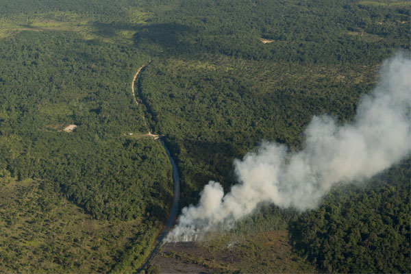
WASHINGTON, D.C. — June 18, 2018 — Winrock scientists have solved the vexing problem of how to remotely measure how much timber is removed from forests and the resulting greenhouse gas emissions. With breakthrough work just published in Environmental Research Letters, Dr. Tim Pearson and his team at Winrock International have developed a new method that combines specialized aerial imagery with mapping and algorithms to automate the detection of extracted volumes and the emissions impact of selective, often illegal, logging.
Previously, selective logging volumes could only be measured on foot, making assessment across vast areas virtually impossible. Winrock’s NASA-funded research identifies a new method that uses remote sensing data to measure the volume of trees logged from tropical forests – including single valuable specimens that are plucked out almost undetectably. While the research uses data from Indonesia, the approach can be used to assess logging and resulting emissions throughout the tropics.
“This method allows us to look across tens of thousands, even millions of acres of forest to find out whether logging has happened and how many logs have been taken,” says Pearson, Winrock Ecosystem Services director. “Protecting the forest doesn’t mean putting a fence around it. This gives us a practical and important new tool to monitor and safeguard one of our most precious natural resources.”
Tropical timber harvest is a big business generating $7 billion in annual exports, but timber harvested from tropical regions is responsible for more than 1 billion tons of carbon dioxide emissions annually, more than double that from all global aviation.
While Winrock had already devised a way to estimate greenhouse gas emissions from logging, that method relied on reports from governments or timber companies, which are often unreliable since illegal logging accounts for over 70 percent of timber exports in some countries. Satellite imagery has also been an ineffective means of forest monitoring. Poachers may take only one tree an acre, since a single tree can sometimes fetch tens of thousands of dollars, and the canopy barely changes when valuable individual trees are removed from a dense forest.
To work around this, Pearson and co-authors used LiDAR (a remote sensing method that uses pulsed laser light that penetrates the canopy to provide a high-resolution three-dimensional representation of the forest) and on-the-ground surveys to create equations that estimate legal and illegal logging and their carbon emissions. The equations use gaps in forest cover caused by the felling of trees and the dimensions of logging roads and skid trails (paths created by dragging downed trees through the woods) to explain up to 87 percent of the variation in data where LiDAR is used and 78 percent where more moderate-resolution satellite imagery is used.
“Timber harvesting is complicated. It’s partially happening below the canopy and it hasn’t been visible with traditional low-resolution satellite imagery,” Pearson says. “But our work has allowed us to combine on-the-ground data with imagery to create the equations. Now governments, industry and independent organizations will be able to monitor logging concessions and illegal logging like never before.”
Art Klassen of the Tropical Forest Foundation says, “We’ve always known that greenhouse gas emissions occur as a result of selective logging, but estimating the amount has always been difficult and prohibitively expensive. This work is an extremely important advance as it uses a practical and simple approach that allows both companies and countries to quickly and easily estimate the GHG impact of logging operations.” Klassen was responsible for all field data collection in the study.
Co-author Stephen C. Hagen of Applied Geosolutions in Durham, New Hampshire, says, “Independent assessments of logging in the tropics have been difficult to come by, but with this research we now have a robust and reliable method of quantifying timber harvests. Having such third-party verification will build confidence, support markets and potentially provide huge development benefits.”
Winrock has long been a leader in providing scientific and data-driven accounting of ecosystem services. It first began exploring ways of measuring carbon emissions from logging in 1998 as part of an early forest-based greenhouse gas mitigation project in Bolivia. In 2014, it developed a first-of-its-kind method for estimating carbon emissions from forest degradation caused by selective logging in tropical regions, a method refined over a period of 15 years and tested across nine countries. Last year, it released a landmark study finding that greenhouse gas emissions from forest degradation in 74 tropical countries is equivalent to 4.3 percent of total global emissions and five times greater than emissions from global aviation.
###
CONTACT